Demonstration Projects
Demonstration projects
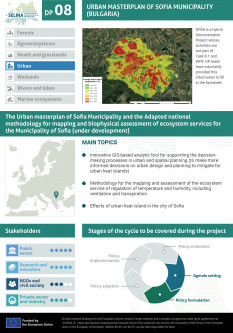
DP08
Integration of Urban Heat Islands and ecosystem services in urban and spatial planning


Develop an innovative analytic tool for supporting the decision-making processes in urban and spatial planning (to make more informed decisions on urban design and planning to mitigate urban heat islands).
Contribute to local climate regulation, more specifically by studying, mapping, and assessment of the effects of urban heat island in the city of Sofia and the development of innovative analytic tools for supporting the decision-making processes in urban and spatial planning.
DP08 will provide evidence on how urban ecosystems mapping can be applied in urban planning, especially by private companies which deal with spatial data through GIS-based applications. The idea is to provide better tools for more informed decisions and integrate the issues of Urban Heat Islands (UHI) and ecosystem services in general into the urban planning processes. More specifically the application will support the risk assessment of UHI effects and estimate the potential impacts from this considering, climate change and the adaptation of the urban environment to this situation. The proposed approach integrates data from UAS with the concept of Local Climate Zones which will be an innovation for the mapping and assessment of urban ecosystems and specifically.
Along with better spatial and urban planning for more livable spaces and cities, the project will also contribute to better and more targeted information on how to integrate more effectively the biodiversity and ecosystem services in spatial and urban planning, better information, potential business model and practices which can be used to build business services, and increased public awareness and competence.